Gunung Bromo (“Gunung” means “mountain” in the local Indonesian language) is an active volcano located in East Java, near the borders of Probolinggo, Malang, Lumajang, and Pasuruan. The mountain is a famous tourist destination and is heavily visited each year despite its active volcanic status. In fact, Mt. Bromo is regarded as the premier tourist attraction in East Java. Included in the Bromo Tengger Semeru National Park, Mt. Bromo sits at an altitude of 2,329 meters above sea level. It is not as tall as some of the other famous mountains in Indonesia, but its unique beauty and charm strengthen its appeal. The actual crater, about 800 meters in diameter, sits within a caldera, or “Sea of Sand,” almost 10 square kilometers in size. The danger area surrounding the Bromo crater is a circle roughly 4 meters in diameter.

A view of Mt. Bromo in the early morning light. Mt. Semeru, the tallest peak on Java Island and an active volcano, can be seen with steam emerging from the cone in the background.
History
As an active volcano, Mt. Bromo has erupted several times over the last few centuries. The regular time interval between eruptions has been 30 years, although the latest eruption began in 2015 and is still ongoing. Interestingly enough, the rocks and debris from this latest eruption have not hit either the people or the religious structures surrounding the volcano. Mt. Bromo itself is only a small part of the wider Tengger caldera, which extends 16 kilometers. The Tengger volcanic complex is approximately 820,000 years old and is comprised of five overlapping stratovolcanos, each with their own, individual truncated calderas. Of these and the volcanoes beyond, Mt. Bromo is one of the most well-known and most-visited.
Mythology and Legends
For the local Tengger people who live in the hills around Mt. Bromo, the mountain has sacred value. The name “Bromo” supposedly originates from “Brahma,” an important deity in Hindu mythology. Once per year, they hold a ceremony called Kasodo, or Yadnya Kasada, beginning at midnight at the full moon between July and August and lasting until early the following morning. This timing lines up with the Javanese calendar. The Kasodo ceremony begins at the temple at the foot of the crater and continues up to the summit. The local people will give up offerings to the Hindu deities, throwing fruits, vegetables, live chickens, and other natural resources directly into the mouth of the crater at Bromo as a symbol of the sacrifices given to their ancestors. These offerings are often vows or gratitude for abundant livestock and agriculture.
Mt. Bromo is located in what was once the Majapahit Kingdom. The local residents believe the origin of Bromo stems from the ancient story of Roro Anteng and Joko Seger. Read the full story here.

A view of the small temple at the foot of the crater, looking across the valley from the summit.
A Sunrise Visit
I had hoped to visit this natural wonder during my stay in Indonesia three years ago, but was never afforded the opportunity. While actively living in Special Region of Yogyakarta, I knew that I could not leave without making a trek out to the volcano. There are many options for visitors choosing to visit Mt. Bromo, but almost all of them include rising before dawn and standing in the hills opposite the crater to watch the morning light spread over the valley. Usually I’m more of an independent and curious traveler, but for convenience I chose to book a tour this time.
I was living in Yogyakarta at the time, so I booked though TourJogja, starting in Surabaya and combining my trip to Mt. Bromo with a visit to Mt. Ijen the following day. You can do research to find a tour that works for you and choose the starting point, duration, cost, etc. to your liking. We took a train from Yogyakarta to Surabaya, arriving at Gubeng Station at around 22:00 WIB. Our driver met us at the station, and we began our journey to Mt. Bromo at 23:30 WIB.
Jeep Rides
There are approximately 1,700 jeeps which carry tourists to the sunrise view points at Mt. Bromo. During the high season, almost all 1,700 of these jeeps are in operation at the same time. This creates some serious problems for the health of the local environment. During my visit, the local people were enforcing an entire month (January 23 – February 25) during which jeeps were not allowed into the caldera in order to allow the local ecosystem a short moment of respite. As my background is in sustainable engineering, I found the incorporation of an entire month to reduce pollution in an ecotourism setting refreshing.

One of the many jeeps used to bring tourists up to the sunrise point at Mt. Bromo. Locals try to make some extra money by offering horse rides to visitors – you can see here that this horse is extremely mistreated and unhappy.
After the drive from Surabaya, our jeep ride began at approximately 2:30 WIB from the village of Cemoro Lawang. Cemoro Lawang is the closest village to Mt. Bromo and the main entrance point to the Mt. Bromo area. If you choose to have a guide like we did, your guide (in most cases) will not be your driver. Instead, the driver will stay with the jeep while you take in the scenery. For two of us, one jeep was definitely large enough. You can comfortably fit four adults into the back of a jeep (six if you REALLY squeeze in there), but if you have a group larger than that, I would recommend that you have multiple jeeps and drivers. Your tour agency or hotel can help you make these arrangements if you need assistance.
Sunrise View Points
There are five view points commonly used to view sunrise from a height over Mt. Bromo: Pananjakan, Sruni Point, Bukit Cinta, Bukit King Kong and Peak B29. Peak B29 is the newest viewpoint and the farthest from the crater, so it sees less traffic than the other four locations. The jeeps can only take you so far – after a certain point, you’ll need to walk. The way is steep and ends in several flights of stairs, but the trail is well-maintained up to the popular viewing platform. You’ll want to wear comfortable shoes, but you can walk as slowly as you need to, especially if you start early.

Sunrise over the village opposite Mt. Bromo. We were lucky enough to visit on a clear day during the rainy season (Nov. – May), but if you do not go during the dry season (June – Sept.), you may not be so lucky.
We thought we were walking slowly, but we still reached the viewing platform by 3:00 WIB. This gave us plenty of time to appreciate the beauty and stillness of the night and try our hands at astrophotography. (My camera was still new at this point and I neglected to bring my tripod along, so I didn’t capture any notable images.) We had an extremely knowledgeable and friendly guide, so he helped us to climb further up the hill than the traditional viewing platforms and take in the valley from both a higher and far less crowded elevation.
Luckily for us, the night was pleasantly cool without being cold. If you choose to visit Bromo Tengger Semeru National Park during the dry season, you may experience temperatures close to freezing and will need to dress accordingly. (Local vendors will insist upon selling you wool hats or scarves, so you may be in luck if you forgot to pack layers). For us, a simple sweatshirt was sufficient.

The view of Mt. Bromo, with Mt. Semeru beyond, just after daybreak from high elevation. The fog in the valley is natural and does not come from the crater.
The Bromo crater is to the west when viewed from the platforms, so you’ll have to split your time between gazing down into the valley and out toward the sunrise. Either way, the views are breathtaking. If you’re more of an independent traveler and dislike large groups of tourists like I do, then I definitely recommend climbing as we did. As you can see from the images below, the lower regions of the viewpoint – the places specifically designed to accommodate tourists – can be extremely crowded, even in the low season. Just take note that the trails to higher points on the hillside are not maintained like the lower regions. If you choose to climb, the way may be slippery, especially if it is currently raining or if there was a recent storm before your visit.
There is a special platform for visitors toward the base of the hill that has architecture commonly found in Hindu regions. There are a few benches here, but around the time of sunrise this platform is absolutely packed with tourists. You’ll see an interesting mix of domestic and foreign tourists in the crowd. If you stay in the lower sections, you can purchase snacks such as pisang goreng (fried banana) and Indomie (instant noodles), as well as coffee and tea, from local vendors. We had to do this because traffic was thick at the time of our descent and we needed time to wait for the road to clear before continuing on our journey, but I always enjoy supporting locals if I can!

The viewing platform at the main Bromo Viewpoint, just after sunrise, packed with tourists.
Javanese Edelweiss
On your way back down from the viewpoint, you may notice many local vendors peddling flowers. The flower is Anaphalis javaica, commonly known as Javanese Edelweiss, and only grows in the alpine zones of the Indonesian archipelago. As a pioneer plant for volcanic soils, it is able to grow in barren landscapes, although it is now characterized as rare. The flowers typically appear between April and August. Interestingly enough, in Bromo Tengger Semeru National Park, Javanese Edelweiss is considered to be extinct. Edelweiss sold by peddlers at Mt. Bromo are white; you may see other colors as well, but these are artificially dyed by the local residents. If you choose to purchase Edelweiss, just remember that import/export regulations are often strict when it comes to agricultural products.


Some samples of the Edelweiss sold by the vendors at the Bromo Viewpoint. Traditionally, the flowers are white, but you can also find purple, yellow, and pink dyes.
The Sea of Sand
Once the sun comes up, you can continue your time at Mt. Bromo by venturing across the Sea of Sand to reach the actual volcanic crater. Beginning back in the village of Cemoro Lawang, we started our descent into the caldera around 6:30 WIB. You may be part of a larger crowd of visitors making the same trek, but due to the vast nature of the Sea of Sand, it is highly unlikely that you’ll feel crowded or rushed.
During our visit, jeeps were not allowed into the caldera because the local people had chosen to give the ecosystem there some time to recover from constant trampling. As someone very interested in the state of the global environment, I appreciated this initiative greatly! The rich volcanic soil in the caldera is still soft from the constant walking of people and horses, so just be prepared to expend a bit of effort as you traverse the area. I imagine that during the 11 months of the year in which jeeps are allowed to traverse the caldera floor, the dust is pretty intense.
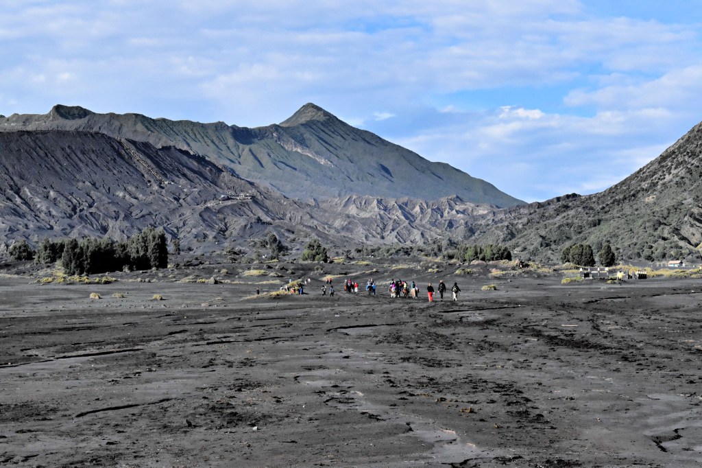
A view of the Sea of Sand and the crater beyond. You can see several groups of people making their pilgrimage across this barren landscape.
The first half, or possible two-thirds, of the Sea of Sand is completely flat. You’ll walk between some grassy “dunes” and may have to cross a gully or two, but beyond that the way is easy. Once you get closer to the crater itself, you’ll start to gain elevation. The way is still flat and not rocky, but it may become slightly difficult to traverse for individuals unfamiliar with moderate activity. I found the walk to be peaceful and pleasant because we weren’t particularly close to any other groups of tourists and the majority of visitors were quite respectful.
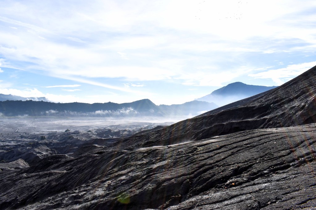
Some shots I was able to take of the Sea of Sand. The earlier in the morning you visit, the more likely it is that there will still be a layer of mist over the ground.
Our guide accompanied us across the Sea of Sand to the crater. At one point, he found a large rock and tossed it high into the air, and when it hit the ground you could hear a genuinely hollow sound coming from the ground below. According to our guide, beneath the caldera is a large hollow a few kilometers thick. Below that is a layer of water, and, finally, below that, is lava. This is something I would have never learned if I chose to navigate the Mt. Bromo region alone rather than with a guide!
Animal Cruelty
My biggest qualm about Mt. Bromo is the obvious presence of animal cruelty in the region. Many of the locals choose to make money by charging tourists for rides on horses, either down to the caldera and across the Sea of Sand, or down the maintained sections of the trail around the Sunrise Viewpoint. However, it doesn’t take an equestrian to realize that these horses are incredibly mistreated. Their suffering is almost immediately obvious to the casual observer (although maybe I only noticed because I tend to keep an eye out for these things).
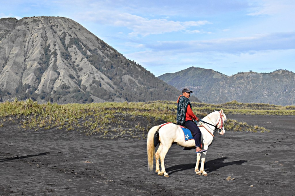
One of the locals sitting astride his horse in the Sea of Sand while he waits for customers.
Many of the horses have been branded, and a few have been branded several times. I believe that this branding is an act of ownership, but it’s highly unnecessary. Beyond that, a large proportion of the horses are lame. You can clearly see this as they walk down the trails, with or without passengers, kicking their hooves out at strange angles or limping. I definitely saw a few horses stumble before being urged on by their owners. Several of the horses are also clearly sick and dying. Visitors, of course, are under no obligation to support this industry. If asked by the locals if you’d like to ride a horse, you can decline with no consequence. The local Javanese word for walk is “melaku,” so simply say it to the horse owners and continue on your way by foot. I found that when I called this out to peddlers offering me rides, they appreciated my (miniscule) knowledge of their local language and would smile or laugh before moving on to other unassuming visitors.
The Crater
Visitors are able to climb the crater and stand on its rim. To reach the top, you’ll need to climb 250 steps (although we counted more than that) to the final point. In Indonesia, it is customary to walk on the left, rather than the right, as in some western nations. Keep this in mind as you climb the stairs and be respectful of other visitors. Although the stairs aren’t that steep, they’re still a bit tiring. We decided to keep moving and just rest at the top, and the climb really wasn’t too bad at all.
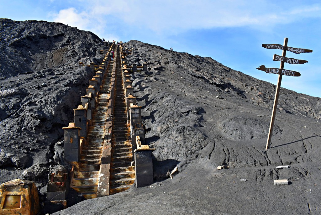
The final steps leading to the rim of the Bromo crater.
At the top of the crater, along the rim, you’ll find a short section with a guard rail, or fence, to protect visitors from falling to their deaths. From your vantage point on the rim, you can see directly into the crater itself and watch the steam from the boiling water drift in the wind. Don’t worry – there is no bad smell associated with this volcanic activity. If you’re lucky and quiet, you may be able to hear the sound of the water boiling below, and if the wind blows in just the right way, you can even catch a glimpse of the bubbles. I found the sight of the actual boiling water to be quite fascinating.
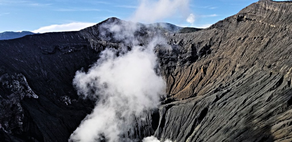
Looking down into the Bromo Crater from the rim.
If you continue along the pathway to the left of the stairs, clockwise around the crater’s rim, you’ll see that the fence ends at a small statue of Ganesha (also known as Gayapati, Vinayaka, or other names), a Hindu deity known as the creater and remover of obstacles. Locals will come here to leave burning sticks of incense as an offering to the god. You do not need to stop your journey here, though, if you wish to get some additional views of the crater itself. The path, although narrow, slightly uneven, and slippery, continues around the rim of the crater. As to the actual distance, I am not certain. While I continued around the rim for a distance, I did not choose to walk to the end of the path myself. I did, however, see a number of other people doing so.


Left: A close-up view of the unguarded path around the crater’s rim. Right: A distance shot of the shadowed side of the crater, with tiny silhouettes of people on its rim.
The walk back across the Sea of Sand is relatively easy, but the climb back up the road to Cemoro Lawang is extremely steep. Make sure you bring water with you, as the temperature rises after the sun comes up and can get hot. You can also choose to buy snacks and/or drinks from the local vendors who choose to sit at the foot of the crater and cater to tourists. When you return to Cemoro Lawang, there are a number of small waroengs (food vendors, not established enough to be restaurants) where you can stop to have breakfast. If your accommodations are local, you can probably also get breakfast there before taking a nap after your eventful morning!
Other Attractions at Bromo Tengger Semeru National Park
The Sunrise Viewpoint and the Bromo Crater are two of the most popular activities for tourists in the Bromo area. I did not stay to check out anything else because I needed to continue my journey across East Java to Gunung Ijen. However, if you’re staying in the area, be sure to check out Teletubbies Hill and nearby waterfalls. Booking accommodations in advance is advised, especially during the high season, because the quality and availability of lodging in the vicinity of Bromo varies, and if you choose to wait too long, you may be disappointed with what is available.
No matter how you choose to do it, you’re sure to have a unique experience at Bromo Tengger Semeru National Park. Stay safe and happy wanderings!

Great post 😁
LikeLike
Wow – looks pretty amazing!
LikeLike