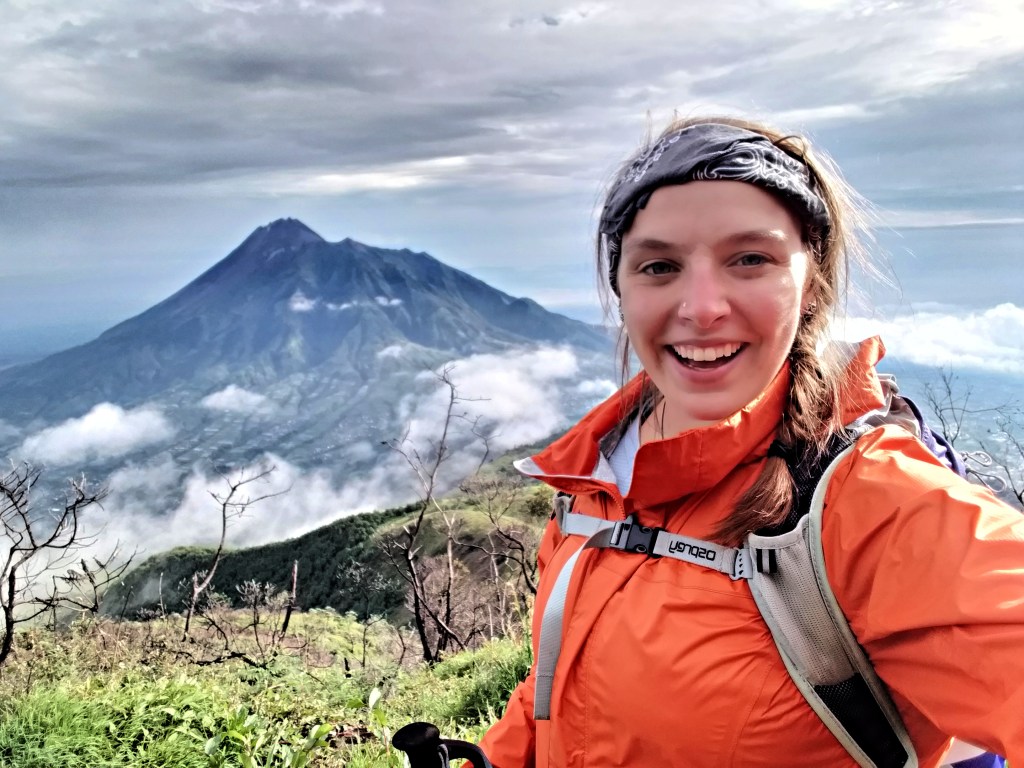
Gunung Merbabu is a dormant stratovolcano located in the province of Central Java, Indonesia. Supposedly, the name comes from the words meru (mountain) and abu (ash), and its last major eruption took place in 1797. The peak of the volcano is 3,145 meters, or 10,316 feet, above sea level. Gunung Merbabu has five calderas, but no serious activity has been reported for a few hundred years now. She is the lesser-known, sister peak of Gunung Merapi, which has been closed to hikers since 2018 due to ongoing volcanic activity.
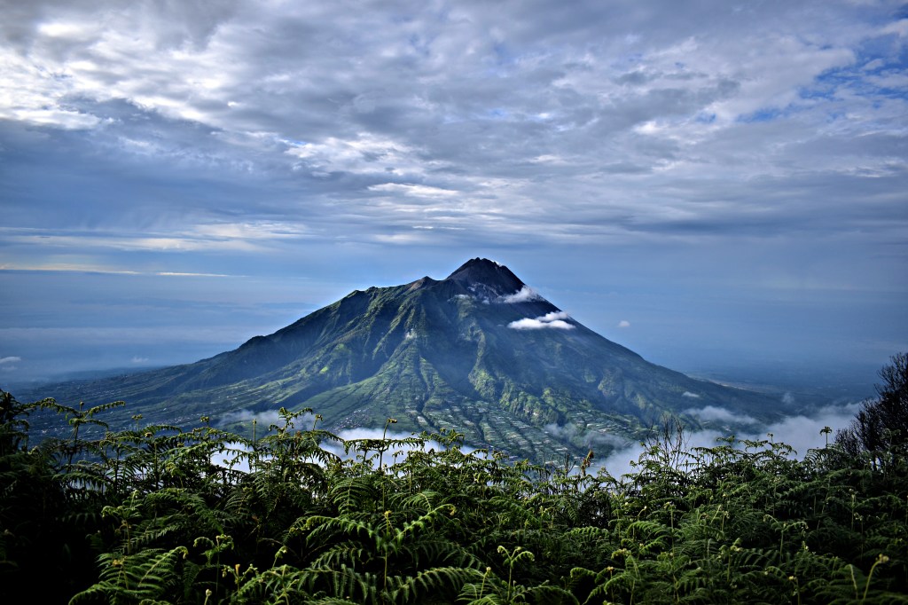
Gunung Merapi as seen from the slopes of Gunung Merbabu.
Gunung Merbabu has gained popularity in recent years as a hiking and climbing location. The terrain isn’t particularly rocky, although it is steep, and the additional, potential dangers include cold air temperatures, thick fog and cloud cover, blistering wind (especially at the summit), lack of water sources, and coniferous forest, which does not sufficiently support survival. These dangers worsen during the night, which is important to note since many hikers choose make an overnight trek to view the sunrise from the summit.
There are two main trails to the summit of Merbabu: the southern route from New Selo, and the northern routes from Thekelan, Cunthel, and Wekas. The north-south routes from Thekelan are longer, but less steep, than the south-north route from New Selo. An additional, third route, the Suwanting trail from the west, has begun to gain popularity. It is not mandatory to hire a guide for any of these routes (although locals in the base camps will try to convince you otherwise), but I chose to hire one anyways since I was going to be ascending solo, at night, and on an unmarked trail. Additionally, I don’t typically hike volcanoes, so in an emergency I wouldn’t know what to do (Merapi had erupted only one week before my trek). If you use AllTrails like I do, only the southern route from New Selo is listed, although it is quite accurate.
My Trek
Nighttime Ascent
I took the most common route to the summit of Merbabu, south to north from New Selo, because it was closest my house to Yogyakarta. Before starting the climb, we stopped at the Merbabu Base Camp, which is also the welcome/entrance point to Mount Merbabu National Park (1800 m). This is where I registered myself as a hiker (safety first!) and paid an entrance fee, although this was all done on my behalf so I’m not sure about the cost. If I had to guess, it was probably Rp. 150,000 for foreigners. No one asked for my KITAS, so I doubt there was a discount for my “not-actually-a-foreign-tourist” status.
We started our Merbabu hike just after midnight. As with many trails, the first 15 minutes or so was flat, so we covered the distance quickly. I was pretty out of shape at the time of this hike (I’d spent the past two months in class and haven’t really exercised beyond the occasional yoga class), so when my guide started up the incline at the same pace as the flat sections, I tried to keep up anyways. Not my greatest idea. I held on for maybe fifteen minutes before confessing that I wouldn’t be able to keep this pace for the entire night.

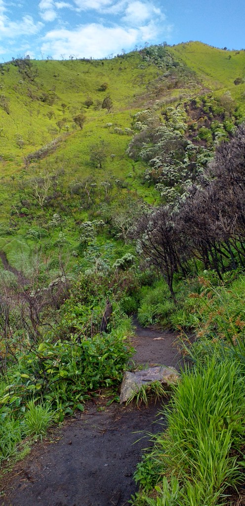
Part of the trail (obviously taken during the descent, in the daylight). It doesn’t look that challenging, but if you look closely, you’ll see white specks on the trail about three quarters of the way up the hill. Those are people.
The climb to Pos 1 (the first checkpoint, also called Dok Malang) took about 45 minutes. I was slightly motivated by the fact that there was a large, loud crowd of college students on the trail with us, and once we passed them I had no desire to let them catch back up. The walk between Pos 1 and Pos 2 (also called Pandean) was shorter and took us approximately 35 minutes. We took a bit of a longer rest at this point before continuing the climb, which turned out to be a great decision, because upon leaving Pos 2, we entered the cloud cover and the temperature dropped significantly.
The trail between Pos 2 and Pos 3 is where the terrain begins to get steep. The forest begins to thin out at this point. Thus, you’re more exposed to the elements, but you haven’t quite passed through the treeline. I stopped checking the time when we reached Pos 3, but I would guess that this section took no more than 30 minutes for us to cover. We left the trees behind completely at Pos 3 and started openly climbing what I will describe as a “vertical mudslide.” At this point, the clouds started closing in and limiting visibility. We closed the distance between Pos 3 and Pos 4 (also called Sabana 1) without stopping to rest, probably in 20-30 minutes.
Pos 5 (Sabana 2) is the last checkpoint before the summit. The section of trail to this point is slightly less steep than than the trail between Pos 3 and Pos 4, but that’s not saying much. Here you’ll encounter what I’ve dubbed the “Sandbag Stairs,” as a decently long staircase of burlap sacks has been wedged into the mountainside to make this section more manageable.

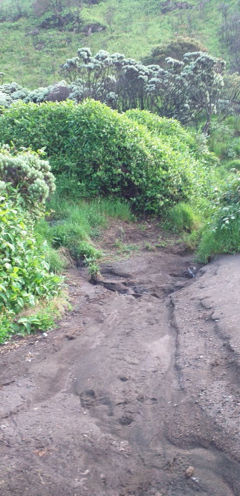
You can see here that the trail in most places is little more than a muddy path. If you’re not careful, you could find yourself following the wrong rut and end up lost, as there are dozens of deer paths crisscrossing the hills as well.
It started to rain as we started our final ascent. This last section of the trail was arguably the most brutal because of the intensity of the wind (howling and freezing cold), the difficulty of the terrain (steep, maybe 65-70 degrees, and slippery mud), and the continuous feeling that the summit was right around the corner (based upon the volume and pitch of the wind). If I’m hiking alone and experiencing conditions like this, I’ll usually stop semi-frequently to catch my breath and make sure I’m not being too hard on my joints. With the wind, low visibility, and rain, I had to keep up with my guide or risk losing him completely in the darkness.

The stars were especially vivid once the clouds dispersed.
We reached the summit just after 3:30 am. I was told that the ascent usually takes 5 hours; we did it in about 3.5 (and honestly, I believe that I was still quite slow – I call it “trudging speed”). At the top, we settled in to wait for the sunrise, which wasn’t until 5:45 am. My guide brought a blanket and tried to take a nap. I, on the other hand, was not so lucky. I had to completely change my clothes, since I had sweated through all my layers on the way up (you could literally wring out my sweatshirt). Despite wearing the warmest clothes I had, I was still freezing. I decided to try my hand at astrophotography just to give myself something to do and keep moving. I had no tripod on this trek, so results were not great.
Sunrise
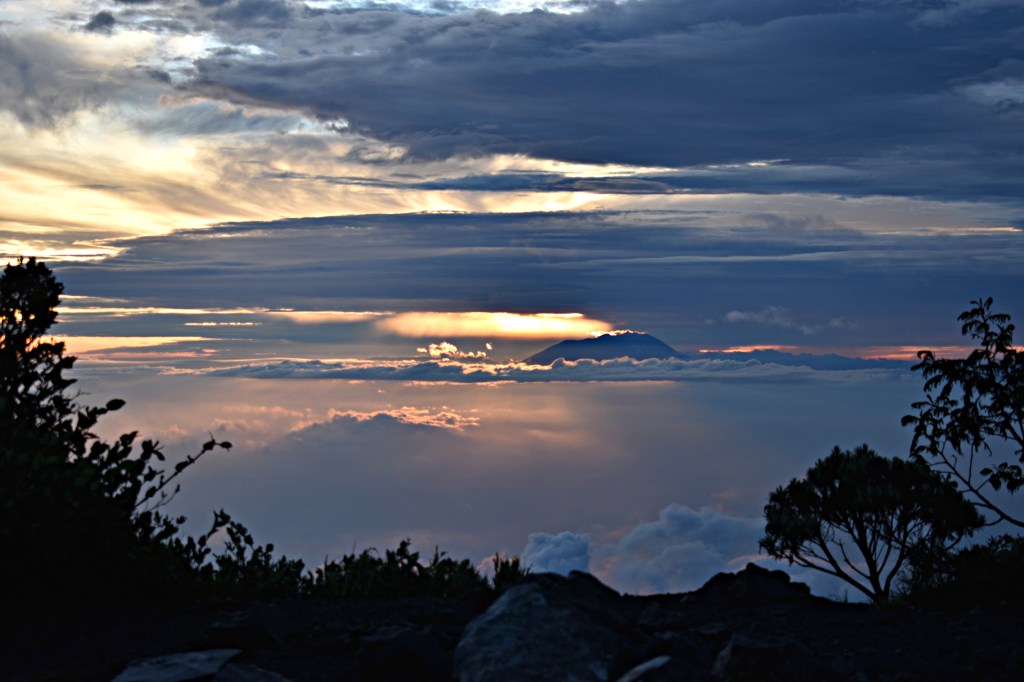
Sunrise was definitely worth the two hours of suffering in the freezing wind. You can see all the nearby mountains from the summit/triangulation point (Gunung Sumbing, Sinoro, Lawu, Merapi, and Ungaran) as well as the cities of Salatiga, Solo, and Surakarta. The clouds, of course, are unpredictable. Since I hiked in the rainy season, we got an interesting view of the valley below shrouded in clouds. Occasionally, the fog rose and blew in around us before disappearing again, but that, too, was a unique experience.

Some early-morning views from the summit of Gunung Merbabu. Left: The sun as it begins to rise over the valley. Right: A view across the Triangulation Point at dawn, with Gunung Sumbing and Gunung Sindoro visible in the distance.
The peak of Kenteng Songo, at 3,142 m, is the official peak of Gunung Merbabu. However, the Triangulation Point, a short walk away, is actually 3 m higher in elevation, at 3,145 m. The two points are only a few meters apart, and you can easily walk the packed dirt path back and forth between the two. The Triangulation Point is arguably much better for watching Gunung Merapi.


Left: Gunung Sumbing and Gunung Sindoro at dawn. Center: Gunung Merapi shrouded in clouds. Right: Gunung Ungaran at dawn.
We were extremely lucky in that we got to enjoy the peak in almost complete isolation. Only one other group of hikers (three European backpackers) were at the summit with us, and they didn’t arrive until after 5 am. We all shared some coffee around the small stove that my guide had brought, and they left much sooner than we did. During high season, you’ll likely find people camping alongside the trail from foot to summit, and larger groups of local and foreign hikers congregated at the summit to take in the sunrise.


Left: The sign marking puncak (the summit) at Kentengsongo Peak. Right: Poor quality photo of me at the Triangulation Point.
Morning Descent
We climbed down the way we had come since my driver was still waiting in New Selo. If you want, you can definitely continue down the opposite side of the mountain from the way over which you ascended. During the descent in the daylight, we could see that the terrain just below the summit is lush and green – full of meadows and Edelweiss forests. The descent also offers breathtaking views of Gunung Merapi the entire way (assuming there are no clouds or fog). There are few trees on the small peaks toward the summit, which explains the intensity of the wind we had experienced the night before. There was also a fire on the slopes here rather recently, which wiped out anything that stood taller than the grass and undergrowth. The primary plants have since recovered, but I can see how sudden fog and storms would make this route extremely dangerous in any condition.
Very excited to get such a gorgeous view of Gunung Merapi!
The descent was absolutely brutal on my knees, even with my trekking poles, and it was one of those hikes where you look back and think to yourself “I actually climbed that??” On our way down, many of the hikers who had spent the night at the various checkpoints were waking up and breaking camp. I was actually surprised that more of them had not joined us at the summit to watch the sunrise, as there were plenty of tents along the way already during our climb. Once we reached Pos 3 on the way down, we took an alternative route that seemed to be cut straight through the undergrowth. The trail was barely wide enough for one person, slippery (I slid SO MANY TIMES without actually falling), and still unmarked.
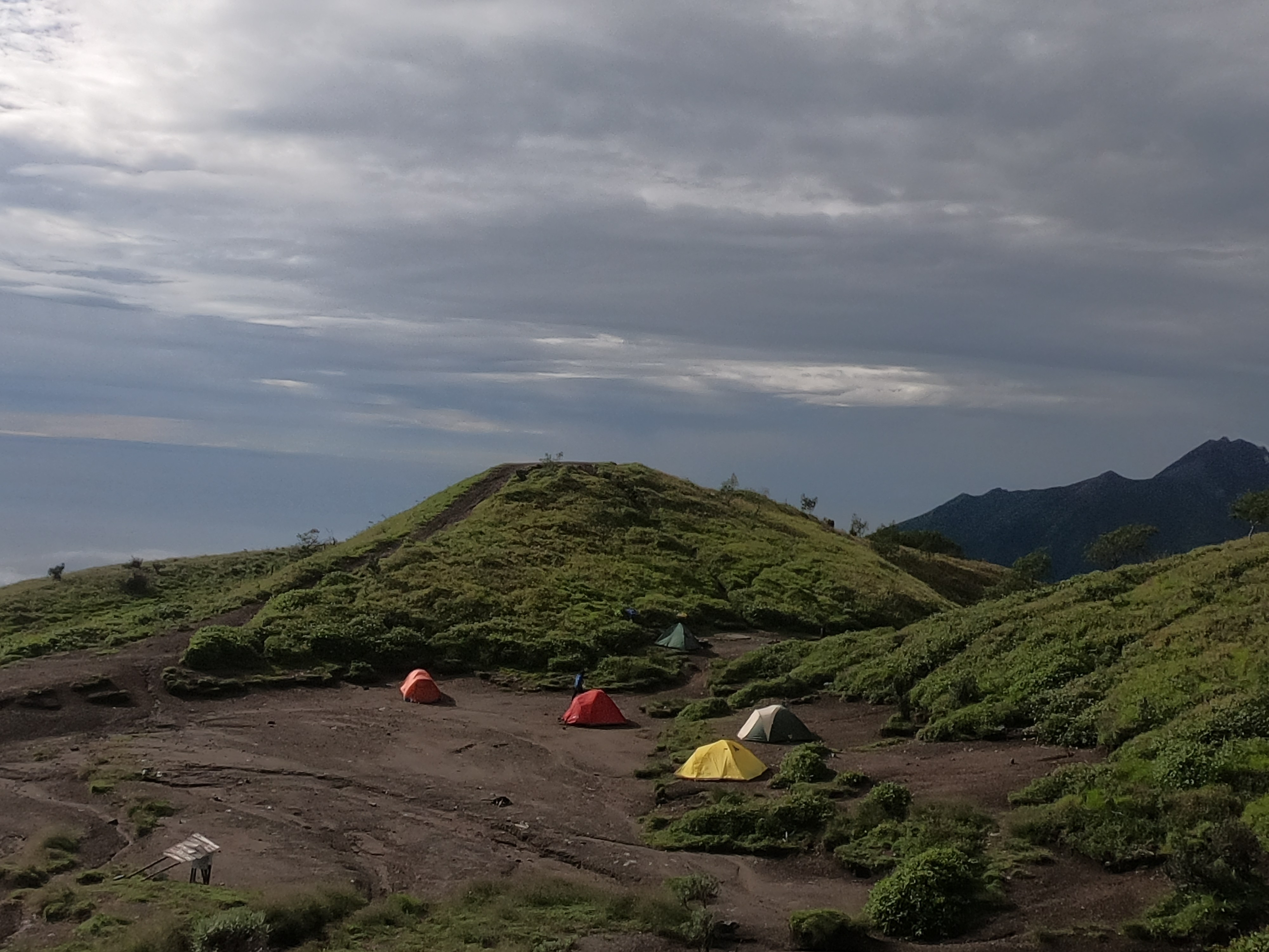
In the morning light, we could see the tents of some of the climbers who had yet to break camp.
We finally emerged on one of the many cultivated hillsides amidst the crops of the local farmers. If I were hiking alone, I would have definitely gone slower to preserve my joints, but I kept up with my guide because I wanted to go home to sleep at this point. I had been awake now for roughly 32 straight hours. We followed a paved path through the patches of cabbage (kubis), onion (bawang), tomato (tomat), and cassava (singkong) before meeting my driver at the porch of a seemingly unoccupied house. I ate a breakfast of fried rice (nasi goreng) with egg (telur) at a local homestay before we drove back to Yogyakarta.
Tips for A Safe Climb
Anyone who chooses to summit Gunung Merbabu from New Selo needs to bring a supply of drinking water from the base since there are no water sources whatsoever along this route. I would highly recommend trekking poles, especially if you’re hiking during the rainy season, and hiking boots or trail runners with decent traction. If you’re hiking at night, definitely bring a headlamp and not a flashlight. The summit can reach temperatures at or below freezing, so come prepared with layers. Additionally, the trail is FILTHY, so please, please, please make sure to “carry in, carry out” and leave the trail in the same condition in which you found it (or better!).
Getting There
Since there are multiple starting points for this trek (Yogyakarta, Selo, Salatiga) and multiple base camps (New Selo, Kenalan, Kopeng), I won’t go through them all. I went from Yogyakarta directly to New Selo without staying overnight, but there are plenty of options for food and accommodation near the base camp so you shouldn’t have to worry about finding lodging.
I left from Yogyakarta at around 9:30 pm and reached the basecamp by 11:30 pm. I should note that just before my hike, the region experienced an extreme rainstorm that caused flooding and some minor landslides, so in better conditions the journey from Yogyakarta at that time of night is probably shorter than what I experienced. I had hired a car just for simplicity’s sake, but you can try to take a taxi, GoJek, or rent a vehicle and make the drive yourself. It should take roughly 1.5 hours. There are ways to reach New Selo by public transit, but they all involve several transfers; it’s probably easiest to make the trip all in one go.
I’ve marked the location of New Selo, the ideal starting point for Gunung Merbabu (and Gunung Merapi, if and when it opens again), below. You can see both Gunung Merbabu and Gunung Merapi positions on either side of New Selo.
Be safe out there, and happy hiking!

Hi, thanks so much for this post 🙂 May I check if you hike yourself or there was a guide (do you advise one)? Also, may I get your advice on how much it cost to reach the place by car- if you could recommend a tour, would be good. Thanks so much!
LikeLike